![]()
Founded 1906
BHAS Field Unit Archive 2003 Page 2
|
|
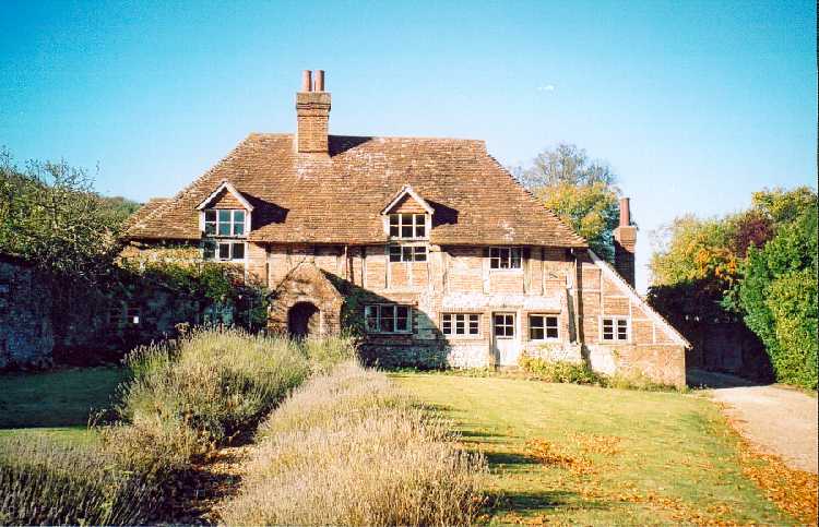
* Original Information May 2003 * added July 2003 * added August 2003 * added October 2003 * added December 2003 EARTHWORK DISTURBANCE AT WHITEHAWK HILL The Brighton and Hove Archaeological Society were alerted by Crispin Kirkpatrick, of Brighton and Hove Rangers Service, that incursions had been made into lands close to the site of the Scheduled Ancient Monument (SAM) of Whitehawk camp. The site at Whitehawk is a Neolithic Causewayed Enclosure and of national importance. The Hon. Sec. Archaeology visited the disturbed area on Friday 15th August 2003. A large terrace had been cut into the side of the hill on the west side of Whitehawk Hill. The cutting is approximately 30 metres south of the Whitehawk television aerial and about 150 metres west of the aerial. A large circular depression has also been sunk, possibly as a cesspit, immediately north of this terrace. An excavating or digging machine had been used as scrape marks were clearly noted in the terrace walls. The site is south of another local incursion created during 2002 by a local character. The site created was apparently used as a platform for a musical 'rave'. An examination of the platform and the surrounding area produced no finds of antiquity, the majority of the terrace being virgin chalk. The wall of the terrace, which is about 1 metre deep at the highest point, produced no features of pits or post holes being cut into the natural chalk. The possible cesspit was not examined, bearing in mind the possibility of the presence of hypodermics needles. The vandalism at Whitehawk, in the creation of these features into the local nature reserve (LNR), does have archaeological implications. The causewayed enclosure does date to the Neolithic period and a feature of this time is also the construction of flint mines, the circular feature could easily be interpreted as such a feature. The terrace, probably used as a platform for the music equipment, has created a flat terrace with a rear wall of chalk that compares both in shape and size, about 15 metres in diameter, to roundhouse terraces found on the Bronze Age settlement sites at Downsview and Varley Halls, Coldean. It is important that this is recorded on both the Brighton and Hove City Council planning maps, and the Sites and Monuments Record (SMR) to ensure that this area, in the future, is not considered and confused with an ancient archaeological site. WATCHING BRIEF AT 3 WINTON AVENUE, SALTDEAN In April of 2003 the Brighton and Hove Archaeological Society were asked to conduct a watching brief in the grounds of the house at 3, Winton Avenue, Saltdean. Archaeological remains of a Saxon burial had been found when an extension had been constructed on the west side of the house, and a badger set was about to be constructed in the north west section of the garden. On April 12th members of the BHAS Field Unit visited the garden and conducted a resistivity survey and metal detecting examination of the area about to be disturbed. The results from the geophysical survey found no evidence for possible grave cuts, and this was endorsed by the metal detecting that also found very little evidence of metalwork lying below the surface. Saxon artefacts would have produced significant readings, particularly swords, spearheads shield bosses. On the weekend of 19th/20th July a greenhouse was removed and a trench cut into the garden measuring 2 metres by 2 metres. On Saturday 2nd August the trench was towelled back and examined by members of the BHAS team and Lisa Rigby of the Rangers Service. The trench and subsequent incursions into the garden for the deepening of the existing fence revealed no evidence for any other Saxon burials. It was noted that the green house area had been levelled and that the natural decent of the land was packed with a layer of chalky loam, which was probably from other areas of the garden, but which may have re-located some of the finds recovered in this trench. The north/west end of the trench measured 0.3m dropping down to a depth of 0.52m on the south east side. The 2 metre square trench did, however, produce some archaeological artefacts, and these are listed below:- Flintwork - A total of 6 flint flakes were recovered from this trench and 6 pieces of fire-cracked flint (Total weight 184gms). The flintwork is all with a white patination and hard hammer struck. There was no sign of retouch of any of the pieces, although one piece of the fire-cracked collection may have been used as an end scraper before burning. Of the flint pieces only 2 items retained fragments of cortex. The flintwork is probably of Late Neolithic or Bronze Age date. Pottery - A total of 3 pieces of pottery were recovered from the trench. One piece is a very abraded sherd of grey ware, but with a soft temper and may be grog tempered. A small piece of pottery is grog tempered ware, possibly East Sussex Ware. One piece has a coarse temper of very small flint inclusions, with a small percentage (5%) of larger pieces of flint temper ( 0.2-0.5mm length). There were also a small number of pieces of mica present. The pottery collection consists of quite small pieces, and all were very abraded. The grog tempered ware could equally be of either Roman or Saxon dating, only a detailed analysis could determine which. The coarse flint tempered piece may be of prehistoric origin. Molluscs - A total of 3 fragments of oyster shell were found among the soil removed from the trenches. Miscellaneous Items - Pieces of contemporary metalwork, tile and ceramics were also found among the soil removed from the trenches. BHAS would like to thank the owners of 3 Winton Avenue for allowing access to the property, to Paul Skinner of Badger Watch, Lisa Rigby of the Ranger Service. GEOPHYSICS AT 'THRAVES' GRAFFHAM, WEST SUSSEX The house named 'Thraves' lies on the southern outskirts of the village of Graffham, West Sussex, nestled in a small valley on the north side of the South Downs. The house was built circa 1410 and is described by Dr Annabelle Hughes as a medieval four bayed hall house. The house has over the centuries been the subject of much structeral alteration. A number of additions to the house are clearly visible from both the front and back of the house. The alterations have included the addition of a chimney, centrally spaced, and a pair of windows cut into the roof. The front door appears central but the rear is offset, but a small extension to the rear of the building may incorporate this doorway. The chimney and the upper windows appear to form some form of symmetry within the early fabric of the building. However, the south end of the structure has obviously been the subject of some dramatic change in recent times. The removal or loss of the south bay of the hall has produced an irregularity in the house design in this area (see photo). The house owner has produced a number of plans of the house and the surrounding area. At one time the house had been the rectory for the church located nearby. The plans showed that over a period of time other buildings had been constructed around the focus of the main house and these over a period of time had changed or had been removed. The BHAS Field Unit was contacted with regard conducting a geophysical survey on the south side of the house to seek possible evidence for the missing fourth bay. During the intervening period a small excavation was conducted by the District Archaeologist south of the existing building. The trench measuring 2.5M by 2.0M was still open when the BHAS unit arrived to conduct the geophsyical survey, and evidence for a robbed out wall footing could be discerned within the excavation. The excavation trench revealed a significant depth of soil and contemporary overburden above the early wall levels. It was anticipated that the results of the geophysical survey would be affected by this depth of earth and rubble. The survey also had to navigate around the remaining spoil heap of the excavation. The geophysical survey concentrated in those areas of the front and rear gardens that were accessible, but despite the restrictions imposed by flower beds, shrubbery and other garden features, a survey of 2 complete grid squares measuring 20M by 20M was accomplished. The survey was a resistivity survey and the images produced show areas of high resistance being discerned as light grey or white in colour, low resistance areas being black or dark grey. The survey to the front of the house (front) produced very little evidence for anything other than the flower beds, a dark linear feature running from the bottom left hand corner of the picture running up and to the north east in the image is the driveway. The lighter area running either side of this dark feature is grass and flowerbeds. The dark area in the south east quadrant is the driveway and grass of the neigbouring house. The rear garden (back) does, however, contain a number of interesting anomalies. The lawn has produced a number of high resistance areas that can clearly be noted. On the east side of the garden, close to the garden wall running down to the roadside is small square feature consisting of 3 possible walls, there appears to be no wall on the north side. However, there is an ephemeral lighter linear link running from this feature in the east to the west side of the garden. This subtle linear feature may be the remnants of an earlier building or an old garden wall. The west side of the garden, has a number of linear features of high resistance. These features measure between 2 and 5 metres in width and may continue in a westerly direction. A seperate rectanguler feature can be noted just to the east of this other linear arrangment, but all the areas of high resistance may possibly be linked. The survey produced no evidence for walls located in the area considered to be the location of the fourth bay of the house, this was anticpated because of the excessive overburden seen in the section of the excavation trench. The resistivity survey of the gardens around the house called Thraves indicate that vestiges of old outbuildings may lie beneath the lawns and flowerbeds. It is not possible to say with certainty exactly what the results prove and how old the features are, often geological anomalies can produce similar results. However, the features being of a regular configuration do suggest possible structures, but only excavation can really determine the nature and date of the features. I would like to thank the houseowner, Mr Peter Hawkes, for allowing access to his garden.
|
||||||||||||
|
|