![]()
Founded 1906
Archaeology Report Autumn 2004
|
|
|
|
|
|
|
|
|
|
|
|
|
|
|
|
|
|
|
|
|
|
|
|
|
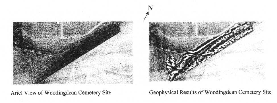
Woodingdean Cemetery Project Background The cemetery at Woodingdean was considered for archaeological investigation after aerial photographs of the area showed soil marks possibly of ancient field systems which are thought to be of the Iron Age/Romano-British period. Research of the Site & Monuments Record show other archaeological activity in the fields which are associated with the ancient field system situated to the north - east. The area of investigation has been designated as a future burial site for the local population of Brighton & Hove and as such, any evidence of archaeological activity will be destroyed at some time in the future. (see aerial view and geophysics ) Resistivity Survey (first phase Woodingdean Cemetery Project) During March and April 2004, the Brighton & Hove Archaeological Field Units geophysics team and other members of the field unit, carried out a full survey of the sheep pasture land by resistivity machines (above right) to investigate the possibility of the ancient field system continuing into the unused pasture land to the north-west, the results proved inconclusive but did produce other anomalies, it was agreed with the local council that assessments of these anomalies should be carried out to ascertain the possibility whether they are a result of the natural geology or archaeology. Assessment (second phase Woodingdean Cemetery Project) The assessment stage of the archaeological project began in July 2004 and is expected to take the remainder of 2004. Members of the society's field unit will place assessment trenches in areas where the geophysics results indicate some form of potential activity whether natural or archaeological. MILLBANK WOOD, STANMER. In 1995 a group from Northampton reported to the East Sussex County archaeologist that they had found a possible Iron Age hill-fort in Milibank Wood, Stanmer. The group also forwarded a sketch of the earthworks that had been observed along with an approximate scale. A number of visits were made to Millbank Wood to examine the features and in February 2004 the BHAS Field Unit conducted a contour survey of the earthworks. In April and May, 2004, the team returned to Millbank Wood to conduct a resistivity survey of accessible areas within the woods and the paddock to the south/east of the tree lined hill-top. The paddock is a peculiar, rhomboid shaped field with trees lining the edges on every side, the main wood is located to the northwest of the paddock. The geophysics team was led by David Staveley and he used his TR Systems resistivity meter to conduct the survey. The survey was set up using 20 metre square grids, with readings being taken at 1 metre intervals. The readings were measured in Ohms. The results proved to be very interesting. The areas within the woods produced a random set of readings but a depression noted, during the survey, produced exceedingly high resistance; the high readings suggest the location of a possible building. The paddock field produced a wide range of anomalies including both linear and circular features, and one cruciform shape of high resistance which may suggest the location of a mill site. Carol White has been visiting the County Records Office at Lewes, as well as studying the Sussex Archaeological Collections. An article written by Heather Warne in SAC Volume 127 (p.189-229) mentions a mill at Millbank during the early 17th century (Warne 1989). There is some documentary evidence to suggest that a gentleman called Millbanke was associated with the same area, so there is the possibiltiy of a named-field connection. A flint road is known, located close by, and it is possible that it is associated with the features in the field. The road drops down the hill from Milibank Wood heading towards Falmer. The results of the survey are being analysed with a view to future archaeological investigations. It is planned to cut some assessment trenches to determine the nature and dating of the features observed in the geophysical survey. This work is being planned for the 2005/2006 seasons. Rocky Clump Excavations continued at Rocky Clump during the summer months. The excavation trench was opened by a further 4 metres to the north to examine the large north/south ditch. The ditch has produced large quantities of animal bone including cattle, sheep, pig and dog, plus a number of small mammals. Among the items found this year were several sherds of beautifully decorated grey ware, and a coin of the Empress Lucilla, wife of Varus (Circa 192-197AD); the coin was recovered from one of the upper layers. The new excavations have followed the ditch as it continues northwards, and has uncovered a terrace with a number of very large pits cutting into the sides. The site was visited by the Young Archaeologist Club (YAC) in May who did some geophysics and field walking, as well as joining in the excavations with the BHAS team. It was planned to open new sections within the trees at Rocky Clump and also in the south field, but the excavations at Barcombe and Woodingdean reduced the team at Rocky Clump so this has been temporarily postponed. Excavations at Rocky Clump are being planned for 2005 and 2006. A new trench, north of the existing trench, will examine animal bones in greater detail and determine whether there is some ritualistic connection in the method and orientation that they are deposited.
|